
Well, virtually to Leechtown, as the former townsite is no more. The townsite area has been renamed Kapoor Regional Park in recognition of the Kapoor family’s long involvement in the area. Leechtown came to fruition in 1864 when gold was discovered in the Leech River area, a tributary of the Sooke River. Nevertheless, gold mining was short lived and over time the town was abandoned.
Why to Leechtown you may ask? Back in 1996, I was looking at a backroads map book along the relatively new rail to trail route, Galloping Goose (1989?). I could see that the trail proper terminated at Leechtown, but the map showed that an abandoned rail line continued north to the west side of Shawnigan Lake. Also indicated, was a gravel Provincial Highway,117.
So, I loaded up my mountain bike with camping gear and set out to see how far north I could ride on the old rail trails past Leechtown. I coaxed my wife to drop me, bike and gear off along Highway 14 in Saseenos, where there was easy trail access for my ride on the “Goose.” More on this later…
Click Here to Download the full Trails Map

For one bike tour this year, I (and Basil) decided to ride on the Lochside Trail from my home town of Sidney south to the junction of the Lochside and Galloping Goose trails in Victoria.
Also at this point, the Trans Canada Trail (The Great Trail) shares the route of the Goose until Kelly Rd. in Langford, then the TCT continues north west to the Humpback Reservoir for access to the Sooke Hills Wilderness Trail heading north.
The Lochside Trail was created in 2001 and is a mix of paved, hard-packed gravel and shared quiet roads. Relatively flat as at one time it was a rail route of the CNoPR (Canadian Northern Pacific Railway, later CNR) and Victoria & Sidney Railway.
Lots to rubberneck at on the way to Victoria and I was blessed with good weather, in fact it was particularly hot day but there was a good amount of shade on the trail to take advantage of.


As I approached the busier suburbs of Victoria, where I haven’t ridden for quite a while, I was pleasantly surprised to see all the safety infrastructure and bicycle lanes created by the city. Much improved since my last visit to this area a few years ago. The smoother decking installed on a few trestles was a welcome relief from the previous worn wood planks that were quite the boneshakers for cyclists.


Soon I was at the junction of the two trails and started off on the Goose to Sooke. The biggest improvement I saw on this section was at the McKenzie Ave. interchange with Highway 1. This took quite a few years in building and “mega dollars,” but the result is a huge improvement from what was before for both road users and cyclists. Very impressive!


Once again, this part of the trail was created from the disused rail line of the CNoPR and is relatively flat for most of the route to Sooke and beyond. A few tunnels and underpasses on the trail to Colwood where there is a tricky crossing across the Island Highway, which required a short ride on Wale Rd. to the traffic light. The photo shows where there are future plans for a pedestrian/cycling overpass here, but when is anybody’s guess!
After that crossing there is another one across Sooke Rd. with a traffic light when leaving Colwood, just before Royal Roads University. From there the trail carries on into Langford and is mostly hard-packed gravel at this point. The next large road crossing is at Veterans Memorial Highway and Kelly Rd., which requires crossing both roads to re-access the trail. Continuing on, Sooke Rd. needs to be crossed once more at Glen Lake Rd. and this is another busy crossing that requires a short ride on shared sidewalks to the traffic light that crosses Sooke Rd.


After that busy crossing, the trail is quite peaceful now for the majority of the remainder of the route. There are still quite a few road crossings to negotiate but have much less traffic and some even have crossing lights.


I mentioned that that the trail was flat, well it is except for three or four places where the high trestles of the railway over creeks were removed (probably dilapidated or non-existent) and replaced with lower than original trestles, I would imagine as a matter of expense. Well, there are some short steep hills on both sides to negotiate to be able cross these lower elevation trestles, be forewarned, change gears!


After Rocky Point Rd. the trail meanders past Matheson Lake in Metchosin where there are peak-a-boo views of the lake and a few trails down to the lake, only one which is rideable, but the lake is worth a visit. There are washrooms there too if required.

Shortly after Matheson Lake, the trail passes above Roche Cove and reaches Sooke Basin, where there are some wonderful views of the ocean and surrounding shorelines. There are some hiking trails down to reach Roche Cove if one desires to do so.


Not far past Sooke Basin, I left the trail via Sooke River Rd. to spend the night at the Sooke River Campground, where I had booked a couple of nights in one of the rustic cabins there.
After a hot and dusty 70km, I was glad to get off the bike, shower and relax for the rest of the day and evening.
After a hearty breakfast the next day at Mom’s Cafe in downtown (actually, uptown from where I was staying!) Sooke, I rode back to where I had left the Goose the day before. I started out on the quiet trail and after about a 1.5km ride, near the 45km trail marker, I came to the Charters Trestle over the Charters River – This steel trestle was originally built in 1918 and recently refurbished with wood and timber decking – very impressive.

Two kilometres farther along the trail was another even more awesome high trestle to ride and cross over Todd Creek. The Todd Creek Trestle was closed in 2017 as it was found to be in a run-down and dangerous state owing to rotting support timbers. Funds were garnered to the amount of over $1.5 million in order to restore the historic 1918 structure. After the extensive repairs were completed, the trestle reopened in 2020 and it is a sight to behold as an outstanding example of a timber railway trestle. A fine job of restoration that should garner the trestle another fifty years of useful life.


Very close by, at the west of the trail, Sooke River Rd. winds its way to the Sooke Potholes Provincial Park where vehicles and recreationalists can access the parking lots and campground areas of the park. During the Summer months, the potholes and river are a very popular area with natural pools and opportunities for hiking, climbing, swimming etc. When riding the trail alongside the river potholes there are many scenic views of the river and rocky areas below.


Adjacent to one of the parking lots is the historic Barnes Station Shelter (unfortunately with some idiot’s graffiti) named after the pre-1980 owner of the 160-acre property. In 1980, the land was purchased by Albert Yuen, who had a dream of building an ambitious “Deertrail Destination Resort and Media Village.” The dream did not realise, and the property went into foreclosure to end up as the parkland that it is today.


Beyond the ruins, the trail peacefully meanders on alongside the Sooke River with peak-a-boo views downward to the river and adjacent landscape. Some very steep grades next to the trail in this area may create an unplanned adventure if too much time is spent rubbernecking while riding!


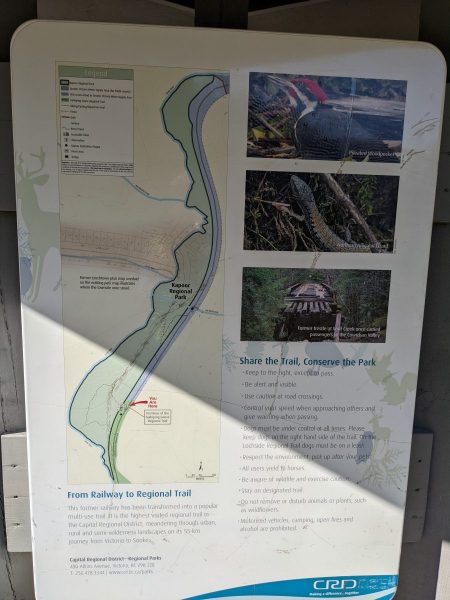
The 55km post is the official terminus of the Galloping Goose Trail and the site of the former location of Leechtown. The area is now Kapoor Regional Park and has a washroom and a rest area with picnic tables.
The first and last photos below shows, as an overlay, where the former town was located in relation to the park…


Although this was the terminus of the Goose, I could see that the trail obviously carries on for a distance and I was compelled to continue riding to see what was now beyond Kapoor Park/Leechtown in the present day.
So back to the beginning story of my travels to this area in 1996…
When I reached this area there was a small contingent of camper trucks, vans, tents etc. scattered on the riverbanks. They were obviously “wild camping” and had driven there via the Boneyard Main logging road. I rode on past them; the trail was now getting a little rougher and I reached a short broken-down trestle at Wolf Creek. Luckily it was a low trestle but only had sporadic old railway sleeper timbers, so I manged to gingerly walk the bike across, and then I could carry on riding from that point.
After about 2km from Leechtown, I reached a small barrier gate with no visual signs that warned me not to proceed. So, proceed I did around the gate (there was a path around) and rode on to reach the banks of Sooke Lake Reservoir. In 1996, the road adjacent to the lake was the Provincial (gravel) Highway 117, which I rode on for a short distance and then noticed some old telegraph poles on my right-hand side over a low ridge. I rode to investigate and realised that the poles were on the old CNoPR railway route right of way. As on the Goose, the rails had been removed so I manged to ride on the old railbed for quite a distance, before being forced to return to the 117 Highway due to the declining condition of the rail bed.
At the end of 117, I reached Sooke Lake Rd., then Shawnigan Lake Rd. at the south end of Shawnigan Lake. From there I accessed a decent trail (now the Cowichan Valley Trail – CVT) on west side of Shawnigan Lake all the way to Renfrew Rd.


I crossed over Renfrew Rd., where I accessed another trail for a short distance before reaching the historic Kinsol Trestle over the Koksilah River – a truly massive structure, but in 1996 it was unpassable (later restored in 2011 and now passable as part of the CVT). This was the end of my 1996 ride on the old rail beds, from then on, I rode back to find a campsite for the night. I made my home the next day via a road route and the ferry from Mill Bay that crosses the Saanich Inlet to Brentwood Bay.
NOTE: I discovered later that there was a bridge, “Burnt Bridge,” crossing the river 5km upstream.
However, it had a formidable gate and would have required a great deal of effort to get the bike and camping gear past/over the gate together with a fair amount of bushwacking on the other side to find the CVT route to Cowichan Lake.
Back to the present day…

Although 55km is the posted length of the Galloping Goose, after leaving Leechtown, I found this marker on the way north to find the gate leading to my old route in 1996.

Finally, I arrived at trail’s end and instead of a flimsy excuse for a barrier that I encountered in 1996, there was this formidable gate and various warning signs that the watershed area is now a restricted area and closed to the general public.

Leaving the gate behind I returned on the trail back to my cabin in Sooke. The next day, I retraced my route along the trails back to my home in Sidney, BC.
So, there we have it, a bike ride 26 years later down memory lane for me! It was a fine trip with very good weather and most pleasing to see all the trestle and trail improvements made since 1996.
In 1998, the gravel Highway 117 was closed as was the CNR right of way in order to increase public control over sensitive catchment lands and remove the greatest threats to Greater Victoria’s water supply.
In 2002 the Sooke Lake Reservoir dam was raised by 6 metres allowing for an 80% increase in water volume. This raising of the dam flooded the surrounded lands; therefore Highway 117 and the old rail bed are submerged forever! Riding my 1996 route next to Sooke Lake is obviously impossible today and access to the whole reservoir area is now highly restricted, so I’m glad that I was able to visit the area as it was 26 years ago!
As the Goose and CNR railbed were part of Canada’s Great Trail in the reservoir area, a new connecting route was developed through the Sooke Hills Wilderness Regional Park to span the gap that existed prior to the closures. The Sooke Hills Wilderness Trail now is the missing link; however, this is no gentle-grade rail trail and is quite rugged with some grades of 16%! Be warned!
Basil enjoyed the ride too, but wished he had a face mask as the trail was very dusty. I vacuumed him off when I got home; he wasn’t too happy at that procedure!
Basil: “I asked for a bath and got vacuumed, typical! I wonder how he’d like that?”
Finis!

Not bad, not bad… Well done Adam.
LikeLike